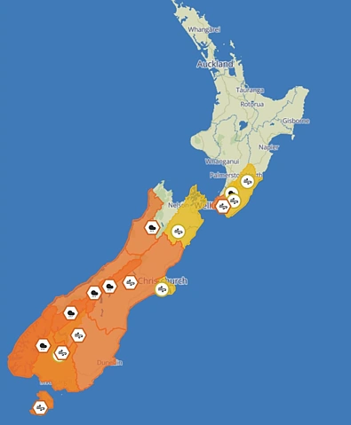
Cold front brings snow, gales and thunderstorms across New Zealand
HouGarden New Zealand, 30 October — MetService meteorologist Alanna Burrows described the conditions to Stuff as a "mobile, windy set-up", with a cold front carrying rain and showers from south to north throughout the day.
NZ Transport Agency confirmed that State Highway 73 between Arthur's Pass Village and Otira closed on Friday morning because of snow. "People are asked to avoid the area or delay their journeys as roading crews seek to clear the road," the agency said. State Highway 7 was also closed due to snow between the turnoff to Hanmer Springs and Springs Junction, a stretch that includes Lewis Pass.
Road snowfall warnings are in place for several other alpine routes: Lewis Pass (SH7), Arthur's Pass (SH73), Lindis Pass (SH8), Crown Range Road and Milford Road (SH94), Burrows said.
Cold air trailing the front is keeping temperatures low in the far south. "Dunedin is in for a high of 10C," Burrows said.
Strong wind watches have been issued for Hawke's Bay south of Hastings and the Tararua District from midday to 9pm, and for the Tasman District — around and northwest of Motueka — from 9am to 9pm. Burrows said it is expected to be a windy day across all of Aotearoa.
Thunderstorms are forecast along the West Coast of the South Island from Friday morning, particularly around Golden Bay and down to Fiordland, Burrows said. "By the afternoon, there could be thunderstorms for the lower North Island as well as the Canterbury Plains and Christchurch," she added.
In the North Island, isolated showers are forecast from Northland through Waikato, Coromandel and the Bay of Plenty. From Waitomo to Wellington — including the central high country and Wairarapa — MetService expects isolated showers turning to rain, with the possibility of heavy rain, hail and squally thunderstorms just south of Taihape. A few showers are expected for Gisborne and Hawke's Bay by the afternoon.
For Nelson, rain is forecast to develop on Friday morning and turn heavy during the afternoon. In the South Island, Buller through to Fiordland, including Southland and Clutha, can expect showers with thunderstorms possible on Friday morning and snow lowering to 400 metres in the south. Scattered showers are expected to spread north across Marlborough to Otago by the afternoon, with possible squally thunderstorms and hail along the Kaikōura and Canterbury coasts.