Spring storm sweeps New Zealand with lightning, hail and frost before weekend clear-up
HouGarden New Zealand, 16 October — MetService meteorologist Heather Keats told TVNZ's Breakfast programme that the overnight storm was a classic piece of unsettled spring weather, bringing rain, hail and widespread electrical activity.
"There were a lot of thunderstorms last night, and Auckland City did get a few of them. Although most of them were offshore, but there were about 588 lightning strikes over New Zealand in the last 12 hours," Keats said.
Wellington bore the brunt of the rainfall, recording between 20mm and 40mm in the 12 hours to 5am Friday. A southerly storm also pushed through Cook Strait during that period. "So that is quite some decent rain and heavy rain as well. Bit of a southerly storm blew through the Cook Strait, so that was a bit of fun too. But look, it is starting to clear, which is very good news," Keats said.
Thunderstorms were still a risk on Friday morning, particularly for the east coast of the North Island, which Keats said would also receive the bulk of the weekend's rain. "Most of those thunderstorms overnight clear out with sunrise, so that's all good. But there is going to be a risk later this morning for the east coast of the North Island," she said.
The Coromandel Peninsula and Great Barrier Island were forecast to see further thunderstorms on Friday afternoon and into the evening, with some of those storms likely to produce small hail. "Some of those thunderstorms will have some small hail too, which is not great for the seedlings that you've just planted," Keats noted.
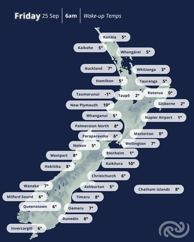
Temperatures on Friday were well below recent highs. Wellington was forecast to reach just 9C, Gisborne 12C, and Hastings — which had come close to 30C earlier in the week — was expected to top out at only 11C. Frost was also possible over the weekend in some areas.
Saturday was expected to improve markedly once morning cloud cleared. "Tomorrow much better, plenty of sun out once that cloud clears," Keats said, though she cautioned that rain would continue to affect the eastern North Island, including Hawke's Bay and Gisborne, due to a lingering southerly feed.
By Sunday, conditions were set to improve more broadly. Wanaka was forecast to return to 24C and Dunedin to 20C. "Sunday is shaping up to be a fantastic day around the country," Keats said. A large high-pressure system was expected to move over the country in the coming week, bringing warmer and more settled conditions, though Keats said temperatures would remain variable. "We're only halfway through spring. Things are going to be like that for a little while longer," she said.
Two road snowfall warnings — covering Lewis Pass on State Highway 7 and Porters Pass on State Highway 73 — were set to expire by 11am Friday.